Planning a trip.
We like to have detailed plans when embarking on a trip of any substantial length.
For many trips, you need to make reservations well ahead of time. Sometimes as far out as a year ahead. Locations such as Disney Fort Wilderness, Arches, Yellowstone, Zion and Bryce National Parks fill up immediately once reservations open for a given time frame. Even the private campgrounds nearby fill up quickly.
Know when reservations open, what the change/cancellation policy is, and be quick. If the change/cancellation fee is small, I will make a reservation as soon as they open and figure it all out later.
RV Trip planning is not much different from any other road trip. You are simply staying in a campground instead of a hotel/inn.
If you are the kind of person who likes to ‘fly by the seat of your pants’ , and you are happy with that, then you will find all of this quite boring and senseless but I feel that we get FAR more out of trips by planning them. This doesn’t mean we are inflexible though.
Covering trip planning is a long description. It is too much to put into a blog post. I have included some details here but I have a complete, and better detailed, document in PDF format you can download here: Trip Planning. This includes more detail with pictures of what you will see.
I hope you find this all helpful and pass it on to your friends.
Planning a local trip is quite different from planning a long trip with multiple stops along the way.
All you need to plan for a local/short trip is where to go. Once you pick a general area/city, you simply need to find/pick a campground.
A good GPS, or driving app, is essential. I greatly prefer Google Maps over any other app or any GPS. I trashed my Garmins and now use only Google Maps since they have managed to provide me with the best .
Campground Apps
The first thing is to pick an app to help you choose where to camp. There are a vast array of these. There any numerous free apps and just as many pay apps. Some try to be all inclusive planning apps but I have never found ANY (not even pay apps) that come truly close to being the one app I need. My go to for finding/picking campgrounds is Campground Reviews. This app is free and you don’t even have to sign up for just the basics but go ahead and sign up (for free) to see all the info offered. You can enter a city in the general area. It will show a map of campgrounds nearby. You can zoom in/out for more or fewer.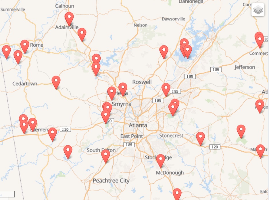
You can also sort by ratings and filter for a variety of items such as hookups.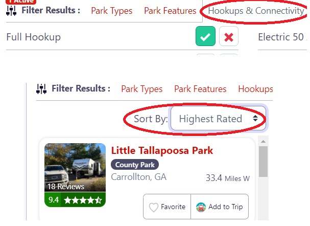
Select a campground and it will give you a ton of info on it including phone #, link to their web site, amenities, pics, maps, reviews, tips, GPS coordinates and so much more.
Driving Apps
Two items you need to be aware of when driving with your RV are height clearances and LP tank restrictions.
There are not many LP tank restrictions but they can make for quite a hassle if you are not aware of them (and possibly a traffic/safety violation). One such location is driving past Baltimore, MD. You cannot drive through the tunnels there with an LP tank without pulling over and getting it first inspected. This takes time so I always take a slightly longer route that takes me on I-695 either South or North. NONE of the apps I have seen cover LP restrictions. I looked up restrictions and found the following:
LP-GAS PROHIBITED:
Maryland/Baltimore: Baltimore Harbor and Fort McHenry (I-95) tunnels. Alternate route for RVs with propane over the Francis Scott Key Bridge is I-695.
Massachusetts/Boston Harbor: All.
New York/East River: Between Manhattan and Brooklyn: Brooklyn Battery Tunnel. Between Manhattan and Queens: Queens Midtown Tunnel.
New York and New Jersey/Hudson River: Between Manhattan and Jersey City: Holland Tunnel. Between Manhattan and Fort Lee: Lower level George Washington Bridge (I-95 South) and George Washington Bridge Expressway. Lower level Verrazano Narrows Bridge. Between Manhattan and Weehawken: Lincoln Tunnel.
LP-GAS RESTRICTIONS:
Virginia/Chesapeake Bay Bridge/Tunnel: RVs equipped with ICC-approved compressed cooking tanks not exceeding two 45-pound capacity tanks (or two permanently mounted containers with maximum total capacity of 200 pounds) may cross the facility provided that, in the opinion of the toll collector or police sergeant after inspection, the tanks are completely shut off and securely attached.
Texas/Houston Ship Channel: Washburn Tunnel between Pasadena and Galena Park: Maximum of two 7½-gallon containers (30 pounds gas each) or one 10-gallon container (40 pounds gas) of DOT (ICC)-approved type, with shutoff valve at discharge opening. Valve must be closed when in tunnel. LP-gas as vehicle fuel prohibited. 7½-gallon containers (30 pounds gas each) or one 10-gallon container (40 pounds gas) of DOT (ICC)-approved type, with shutoff valve at discharge opening. Valve must be closed when in tunnel. LP-gas as vehicle fuel prohibited.
Keep in mind that this list is NOT all inclusive and you may encounter restrictions in the most unexpected place. Just keep your eyes open for signs.
Height restrictions can cause serious damage to your RV if you miss the sign(s). Know the actual clearance of your RV. Measure from the highest point to the ground and add a several inches – they may have paved the road with 3 inches of blacktop since the sign was put up. I have stickers I mounted on the display for my rear/back-up camera so that I never forget.
As long as you are on an interstate highway, you should be quite safe (given that trucks run the same roads) but stay alert for signs at all times.
Numerous RV apps (such as RV Trip Wizard) do include height warnings and some may even work with your existing GPS system (like Route-1). However, I do it the hard way and look up each road I might have concerns about. If you are just worried about getting to a specific campground from interstate, call the campground and ask if you need to take a specific route in to avoid ANY road restrictions.
You can always search the internet for info height restrictions where you will be traveling. I use a tedious method of looking on Google maps. I first locate the area of concern and go to satellite view (click on icon in lower left) and follow my route along looking for bridges, underpasses, and such. I zoom in closer on any that catch my eye. 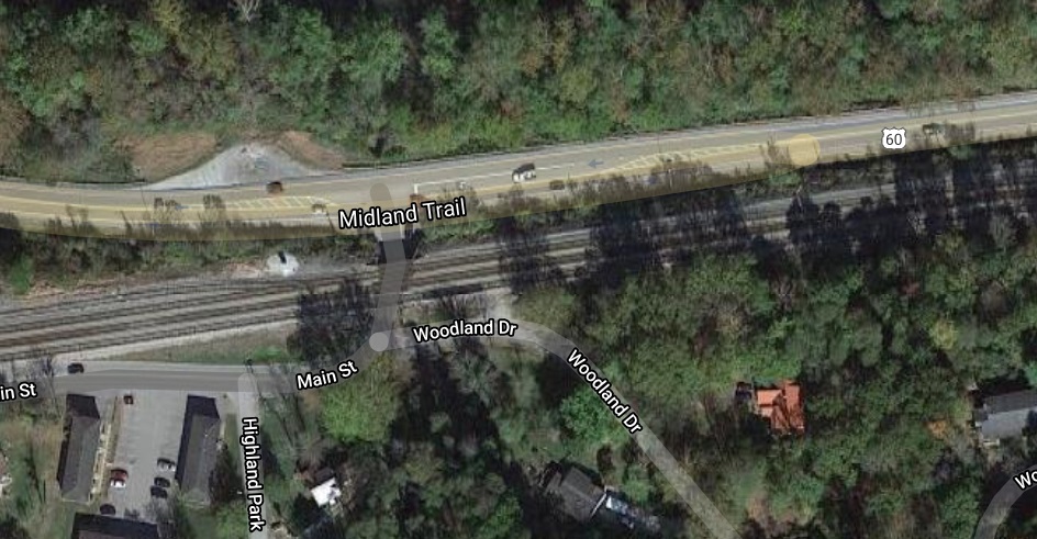
I then switch to Street View by clicking on the little yellow man ![]()
(lower right corner) and drag him onto the road I will be on.
I can now see any posted clearance signs. The only problem is when some township neglects to post the clearance. I would simply use somebody watch as a spotter for me. I’d rather have a few people get fussy about waiting for me than rip something off the top of my RV.
One other item of concern may be road grades – how steep the road is. As long as your brakes are good and tow vehicle adequate for the job, you will not have any great concerns here but it’s nice to be aware of steep grades BEFORE you get there. Also, you may want to pull over on a long uphill grade to allow your engine and transmission to cool of if you have any concerns or let your brakes cool down.
Short/local Trips.
Simple: just use the tools and apps listed above to pick your campground.
Make reservations to be sure you have a spot. If they do not accept reservations, consider taking your RV there on several days ahead of time – especially before a weekend and just pay for the extra days and leave it there.
Check you driving app and various other resources to know if you have to consider any route changes due to too-tight turns or weight/height restrictions.
Enjoy your short trip.
Long multi-location Trips.
Long trips can be a real challenge. There is always the risk of delays so be sure to leave ‘buffer’ days along the way. These also give you a chance to relax and recharge. Just plan to kick back and mellow out.
People have a wide range of what they consider to be how far to travel in a day. Part of this goes along with how fast they drive with their RV. This is all up to you but consider these factors. Speed directly relates to mishaps. It’s purely scientific : the faster you go, the more dangerous it is. Driving faster means stopping is harder, controlling sway is harder, wind can have a greater effect on you and more. The funny thing is speed does not save you much time. If you travel 400mi at 65mph, it takes you 6hrs while 80MPH takes 5hrs. Is it really worth the extra risk?
We plan on a 6 hour, more or less, trip per day. That way we are never worn out from a long drive and can still enjoy an evening at out one night stay. We are also over 60 so you may want to go for a longer day. Just remember, you will still have some set-up and take-down at the one-night stop.
Other things we like to consider for our one-night stays is to NOT be too close to the highway. It’s too easy to want to get back on the road quickly but a noisy site can make for a restless night.
The planning stage:
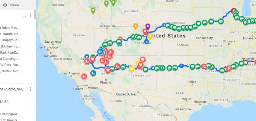
Once you know all the places you want to visit, you need to figure out how many days you need for driving from one to the next. Some apps will help you with this. The program I use is no longer available. An alternative is to use Google maps and do each day at a time. You may have several legs to your trip that are multiple days apart but the process from one to another is the same.
Enter your starting location and the first destination you want to vacation at (I used New Orleans for these examples). Google will give distance and driving time. If you do not want to drive at 65mph, or even faster, then use the distance and divide at what you want to consider to be an average speed for the entire day. I use 50mph and this works fine. It allows for a lunch break and a few rest stops / gas stops/ pee stops.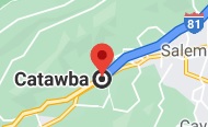
Once you have a distance for this day, look at the distance, and driving time, to determine how many days you want to use for this leg and divide the total distance for how about how many miles per day you need to cover.
Now, drag the ending marker back up the path to about where you think would be the proper distance. You will see the distance under the driving time in the left panel.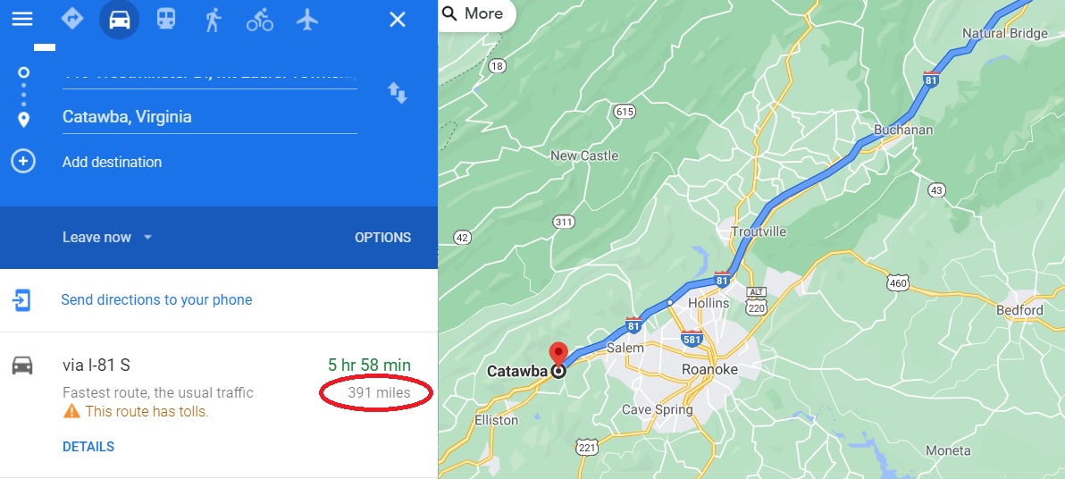
Keep adjusting the marker until you are happy with the distance and near a town.
Now you can search for campgrounds nearby campgrounds. Once you settle on a campground, enter it into maps as your new map destination. You can save this map to your favorites to use later for driving the actual trip.
Use the reverse arrows to swap the trip ends and make the campground your new starting point.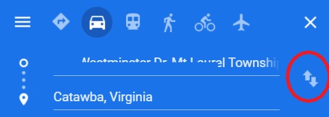
Put the location of your destination in again. Now the map is from stop 1 to the destination.
Repeat the previous steps to determine your second stop. 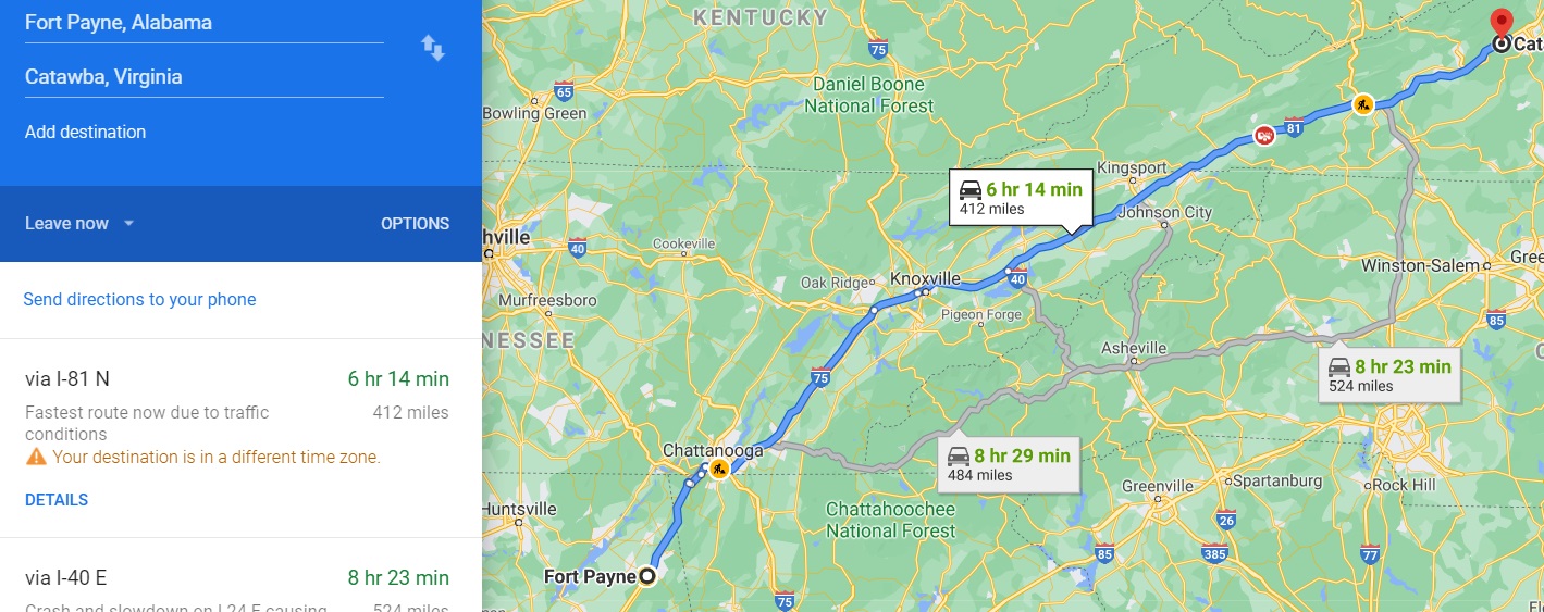
Once again, you can save this map to your favorites to use later for driving the actual trip.
Repeat as needed to complete this leg of the trip.
If you need to plan multiple legs, simply repeat the above process for each one.
This may not be the most glorious approach but I have yet to find ANY app that serves as a driving (GPS) app anywhere nearly as well as Google Maps and want my maps to be saved on my phone and ready to go. I use Chrome as my browser on my I-phone AND my PCs so I can do the work on my laptop, save each day’s trip to a bookmark folder, and then later see it on my phone since they are synced.
You can also turn on rest stops on the map as well as find gas stations and restaurants.
I hope you find this all helpful and that enjoy many a hassle free trip.